ΠΡΟΠΤΥΧΙΑΚΑ
ΠΕΡΙΠΛΟΥΣ: ΨΗΦΙΑΚΗ ΕΦΑΡΜΟΓΗ ΙΣΤΟΡΙΚΗΣ ΓΕΩΓΡΑΦΙΑΣ ΣΤΟ ΕΚΠΑ

Περίπλους: ψηφιακή εφαρμογή ιστορικής γεωγραφίας στο ΕΚΠΑ
Από τον Μάιο του 2024, λειτουργεί στον κυβερνοχώρο του ΕΚΠΑ η ψηφιακή εφαρμογή ιστορικής γεωγραφίας ΠΕΡΙΠΛΟΥΣ, που είναι αφιερωμένη στη μελέτη και τεκμηρίωση της κλασικής αρχαιότητας μέσα από τα κείμενα των αρχαίων γεωγράφων. Σκοπός του Περίπλου είναι να αποτελέσει ένα χρήσιμο, εύκολο, και προσιτό εργαλείο για ερευνητές, φοιτητές, μαθητές και κάθε άλλον ενδιαφερόμενο για την αρχαιότητα. Καθώς μάλιστα είναι δίγλωσσος (ελληνικά – αγγλικά), ο Περίπλους απευθύνεται σε ένα ευρύτατο κοινό διεθνώς.
Ο Περίπλους υλοποιείται στο πλαίσιο του συνεργατικού ιστοτόπου ArchaeoCosmos, που ανήκει στο Τμήμα Ιστορίας και Αρχαιολογίας του ΕΚΠΑ και είναι αφιερωμένος στην ιστορική γεωγραφία της Μεσογείουκαι της Εγγύς Ανατολής από την Προϊστορική Εποχήέως και την Ύστερη Αρχαιότητα.
Ο Περίπλους αποτελείται από τρία μέρη:
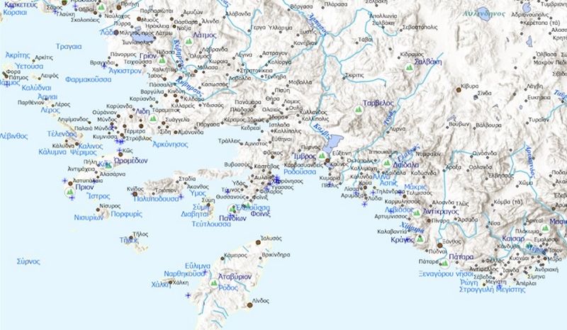
- PeriplusAtlas. Πρόκειται για τον πληρέστερο ως σήμερα ψηφιακό χάρτη ολόκληρου του γνωστού αρχαίου κόσμου, από την Ιρλανδία έως και την Ινδία, και με χρονικό εύρος από τους Ιστορικούς Χρόνους έως και την Ύστερη Αρχαιότητα. Εκτός από τους αρχαίους οικισμούς, ο χρήστης μπορεί να επιλέξει στον χάρτη τα βουνά, λίμνες, νησιά, ποτάμια, περιοχές κ.ά. Για κάθε σημείο στον χάρτη, ο χρήστης λαμβάνει επιπλέον πληροφορίες (εναλλακτικές ονομασίες στα ελληνικά ή λατινικά, χρονολόγηση, σύνδεσμο στην Wikipedia κ.ά.). Μελέτη συγκεκριμένων γεωγραφικών τόπων μπορεί να γίνει και με το ειδικό πεδίο αναζήτησης με το οποίο είναι εφοδιασμένος ο χάρτης.
- PeriplusLogos. Πρόκειται για κείμενα της αρχαίας γραμματείας, όπου θα αποδελτιωθούν σταδιακά οι γεωγραφικοί όροι που απαντούν σε αυτά. Για την ώρα, είναι διαθέσιμος μόνον ο Περίπλους της Ερυθράς Θαλάσσης, ένα γεωγραφικό κείμενο του 1ου αι. μ.Χ., στα αρχαία ελληνικά, στην αγγλική γλώσσα, καθώς και σε νέα ελληνική μετάφραση. Όλοι οι γεωγραφικοί όροι στο κείμενο είναι ενεργοί υπερσύνδεσμοι που οδηγούν στο αντίστοιχο σημείο του ψηφιακού χάρτη.
- PeriplusApp. Πρόκειται για ένα σύνθετο λογισμικό (σε Python και JavaScript), το οποίο επιτρέπει στον χρήστη να αποδελτιώσει τους γεωγραφικούς (και άλλους) όρους σε ένα κείμενο, οποιασδήποτε χρονολογίας και σε οποιαδήποτε γλώσσα. Το λογισμικό δημιουργεί εντελώς αυτόματα τις αντίστοιχες ιστοσελίδες, έτσι ώστε o χρήστης να μπορεί να δημοσιεύσει κείμενα στο διαδίκτυο.
Ο Περίπλους λειτουργεί ως αποθετήριο ελεύθερης πρόσβασης. Οι χρήστες μπορούν να χρησιμοποιήσουν το PeriplusApp, ελεύθερα, και χωρίς κάποια συνδρομή κλπ, για να αποδελτιώσουν κείμενα, και να δημιουργήσουν ατομικούς ψηφιακούς χάρτες (Web Maps), που εύκολα μπορούν να προστεθούν σε εκπαιδευτικές, ερευνητικές ή και ψυχαγωγικές ιστοσελίδες.
Periplus: a new digital application of historical geography at NKUA
From May 2024, the digital application of historical geography PERIPLUS, which is dedicated to the study and documentation of classical antiquity through the texts of ancient geographers, has been operating in the cyberspace of the University of Athens. The purpose of Periplus is to become a useful, easy, and accessible tool for researchers, university and high-school students, students and anyone else interested in antiquity. As it is bilingual (Greek – English), Periplus addresses a very wide international audience.
Periplus is implemented in the framework of the collaborative website ArchaeoCosmos, which belongs to the Department of History and Archaeology, and is dedicated to historical geography in the Mediterranean and the Near East from the Prehistoric Era to Late Antiquity.
The Periplus consists of three parts:
1. Periplus Atlas. It is the most complete digital map of the entire known ancient world to date, from Ireland to India, and with a time range from Historical Times to Late Antiquity. In addition to the ancient settlements, the user can select mountains, lakes, islands, rivers, regions, etc. on the map. For each point on the map, the user receives additional information (alternative names in Greek or Latin, dating, link to Wikipedia, etc.). The study of specific geographical places can also be done with the special search field with which the map is equipped.
2. Periplus Logos. These are texts by ancient authors, where the geographical terms that correspond to them will be gradually collected. For now, only the Periplus of the Red Sea, a geographical text of the 1st century CE, is available, in ancient Greek, in English, as well as in a new modern Greek translation. All geographical terms in the text are active hyperlinks leading to the corresponding point on the digital map.
3. Periplus App. It is a complex software (in Python and JavaScript), which allows users to extract geographical (and other) terms in a text, of any date and in any language. The software creates the corresponding web pages completely automatically, so that users may publish their own texts on the internet.
Periplus operates as an open access repository. Users can use the Periplus App, freely, and without any subscription, etc., to edit texts, and create individual Web Maps, which may easily be added to educational, research-oriented or even entertainment-aiming websites.
